
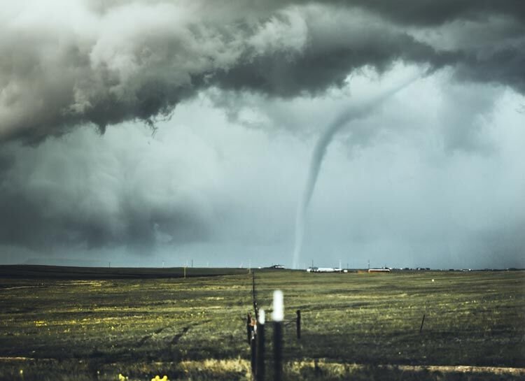
A tornado touches down near a distant farm on what was a sunny day before a storm front’s arrival.
Spring officially begins Saturday and here in Oklahoma that means more than trees and flowers will be awakening from their long winter nap.
Spring also ushers in the state’s season for severe storms and the tornadoes they spawn.
It pays to educate oneself and never take tornadoes for granted.
In Purcell, that includes heeding a reminder that the city has no public storm shelters.
Even lifelong residents of the state can benefit from a seasonal refresher course like the following information published by the National Weather Service:
What is a tornado? NWS defines it as “a violently rotating column of air that is in contact with the ground.”
Wind speeds in a tornado range from 65 to 318 mph. That high end is the greatest wind speed ever recorded and it occurred right here in central Oklahoma on May 3,1999.
Circulation that doesn’t reach the ground is defined as a funnel cloud. Even though not technically a tornado, funnel clouds are capable of inflicting damage to structures.
Remember, the NWS advises, “your safety depends on being constantly aware of the possibility of severe weather.”
The NWS issues a tornado watch when conditions in and near the watch area are favorable for severe thunderstorms and tornadoes to develop.
The watch area is typically large and may include multiple counties
The purpose of the watch isn’t to frighten, but to give you time to review your storm safety rules.
It may be sunny and clear when the watch is issued, but weather can – and often does – change rapidly.
The stakes are raised considerably with a tornado warning.
This means a developing tornado has been detected by the NWS using Doppler radar or reliable sources have reported one on the ground.
A typical tornado warning will last no longer than 45 minutes.
The footprint is much smaller than for the watch.
“If a tornado warning is issued for your county, you should seek shelter immediately,” the NWS advises. “If you see a tornado or feel threatened, move to a safe place immediately. Precious seconds can save your life.”
So what are those rules?
It all depends on where you are when the warning is issued and the sirens sound.
If you are in a home or small business, go to the basement or a small interior room such as a closet, bathroom or interior hallway.
It is imperative your chosen spot be on the lowest level and without windows.
“ Put as many walls between yourself and the outside as possible. If possible, get under something sturdy, such as a heavy table, or use a mattress to protect yourself from flying debris.
“Most injuries associated with high winds are from flying debris, so remember to protect your head.”
If you have one, it’s a good idea to don a helmet for additional protection from head injuries.
Should you be in a large business, school, hospital, shopping center or factory, go to the designated shelter area. If no shelter area is available, find an interior hallway on the lowest level.
Avoid structurally weaker portions of these buildings (windows and rooms with expansive roofs).
There is NO safe haven in a mobile home
Seek shelter in a sturdy building or storm shelter. If there is not one nearby, go to the most interior windowless room (interior bathroom or closet).
Like mobile homes, a vehicle isn’t a safe place to be during a tornado.
If there is a sturdy shelter nearby, get in it. If not, leave the vehicle and lay flat on the ground in the lowest spot you can find. Remember to cover your head to protect it from flying debris.
Though it may look like shelter, do NOT take cover under a bridge or overpass.
These structures can actually generate increased wind speeds during a tornado due to a tunneling effect.
The NWS also advises it is past time to put to rest an old belief that opening windows will lessen damage to a building in the event of a tornado.
Simply put, that is not true.
What is true is this:
“Your safest course of action is to take shelter immediately when a tornado warning is issued for your area.”


Comments
No comments on this item Please log in to comment by clicking here